 |
Our virtual cities lack a great following because our ability to see and explore them has been limited in opportunity. We are satisfied clicking on two-dimensional maps and bringing up linked Web pages that show pictures of what sits on that spot or has sat there before. We can even watch a movie that shows off virtual city models or digitizes a backdrop for a dramatic film. There are options for seeing 3-D models on the Web. You can download software and walk about in three-dimensions within a virtual model. These models should include our cities. By learning how to view 3-D content on the Web, we build a marketplace for our virtual cities. One by one, we can become more intimate with the possibility. This page can get you started.
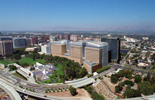
Don't get me wrong, there are beautiful examples of virtual walking tours on the Web that provide us with a sense of our cities in three-dimensions. Take a look at Virtual Bath, Virtual Seattle, or Virtual Helsinki.Our 3-D virtual cities should incorporate links that let us access this existing content. Virtual buttons let you open linked Web pages to see high-resolution pictures of buildings or a 360-degree surround panoramic images enabled through Quick Time or other plug-in application. Planet 9 Studios deserves some credit for generating some of the first virtual cities, like virtual San Jose seen to the left here.
|
|
3-D Web History |
Building Virtual Cities |
Viewing Virtual Cities |
Virtual Cities History |
Historical Preservation |
More Links...
To take full advantage of our natural ability to experience 3-D structures and recognize our way on a never seen street, we deserve a virtual city we can walk through or fly over as if in the real world. We have various options for doing that today: We can use our Web browser to walk through a VRML or X3D model after plugging an appropriate viewer into our browser; we can drill down to a city from space and walk through it as it appears upon arriving within range; we can load our virtual city into another application like a flight simulator and use that specialized software to navigate around. By building our virtual city model flexibly, all these opportunities become possible.
Using a Web-browser Plug-in Viewer
If you want to reward community-built standards (even if the community wasted a lot of venture capital figuring it out), consider viewing your virtual cities in a VRML97 or X3D viewer. To use them, you download the software from a distribution Web site and follow the install instructions to plug the software into your browser. We're still at the stage where viewers are operating system specific unless you want to dive in a little deeper and build the Xj3D viewer which is cross-platform Java-capable. Xj3D took me a half hour to configure and build on my MacBook Pro (and a similar effort on my XP-driven Dell Inspiron laptop).
Go ahead and download the virtual San Diego content that we referenced in the Building Virtual Cities page. Virtual San Diego works in Xj3D and all the other VRML viewers mentioned here.
If you use a Microsoft-owned operating system (like Windows 2000, XP, or Vista), consider rewarding the long-term VRML proponents who have helped create the X3D standard. Parallel Graphics was started by long-term VRML community residents. Their
Cortona Client includes all the latest X3D features which is working towards providing high-quality, video game style virtual city capabilities. Tony Parisi's company, Media Machines produces the Flux Player Client which continues in development and shows much promise in popularizing X3D again.
On a Mac Motorola or Intel chip-based machine, consider trying out the FreeWRL viewer which is open source code sponsored by the Canadian government or Cortona for Mac OS X, a version generated by Parallel Graphics to have similar interface to their more popular version.
Consider trying other viewers suggested by the VRML Plugin and Browser Detector guide provided by NIST. Some are older or less known now, but possibly quite useful for your needs.
Using a Whole Earth Viewer
To take advantage of drilling down from space to virtual city content, consider using Google Earth which is wonderfully capable on Windows 2000, XP, Vista, or Mac OS X. Google Earth is proprietary, but developed over many years as the Keyhole Earth Viewer before Google purchased the company. Or, if you wish to be true to the open source movement, try out NASA World Wind and the emerging NASA World Wind Java which is reasonable to extend with community open source code for Java programmers. Planet 9 includes virtual San Francisco, Los Angeles, and Las Vegas for use with NASA World Wind. Grab them from the Planet 9's Demos and Downloads launch pad.
Using other applications
Java 3D provides a platform for delivering virtual cities to the world via the Web. Java 3D comes with VRML, X3D, and 3DS loaders, among other developed loaders that can be found on-line. The JOGL and the OpenGL community mentions other OpenGL bindings as well. Look for content and viewers based on these open source projects in the near future.
|
|